Harbor Dredging: Centerport, Northport, Duck Island
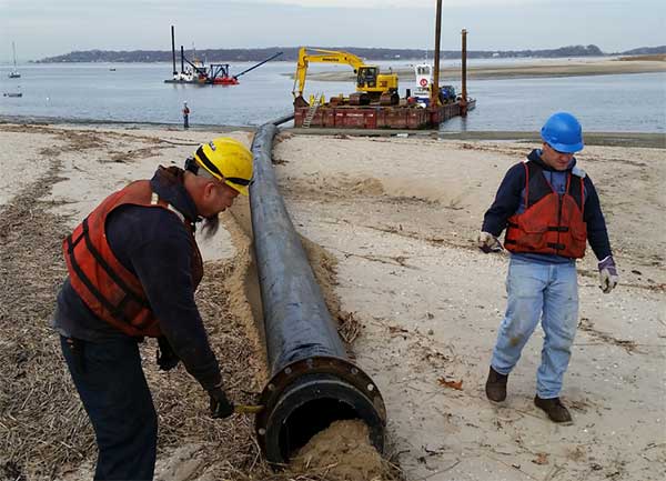 |
| SCDPW Centerport Harbor Dredge Project (Dec 2014) |
Centerport Harbor (County Channel)
In December 2014, the Suffolk County Department of Public Works (SCDPW) dredged the channel leading from Northport Bay into Centerport Harbor.
The dredge operated 24-hours a day, 7-days a week to create a 150 foot wide channel 3,700 feet in length. Approximately 48,000 cubic yards of material was removed to create a channel depth of 12’ at Mean Low Water.
About 30,000 cubic yards of sand were pumped and spread onto the Huntington Beach Community Association shore front, while the remaining 18,000 cubic feet were pumped to Fleets Cove Beach. That sand was apportioned to Fleets Cove with the remainder being transported by truck to replenish the Town’s West Neck and Hobart beaches, respectively.
In addition to improving navigation, the increased channel depth is expected to result in better tidal flushing into Centerport Harbor, removing nitrates and pathogens from the inner harbor and re-oxygenating the water leading into Centerport’s Mill Dam to combat hypoxia.
Northport Harbor (Federal Channel/County Channel)
Current navigation leading into Northport Harbor is actually comprised of two channels:
1) Federal channel maintained by the United States Army Corp of Engineers.
2) County channel maintained by the Suffolk County Department of Public Works.
The Federal channel begins where Northport Harbor meets Northport Bay and proceeds in a southerly direction to the Northport Village Dock near the foot of Main Street, Northport. The County channel begins at the Village Dock and proceeds west and south, terminating near the Britannia Yachting Center.
The challenge of dredging both channels is where to place the silt that encompasses the uppermost layer of the sea bed along the channel. When Northport Harbor was last dredged in 1963, the silt spoils were placed in salt marsh at the southern tip of Northport Bay, just north of Route 25A in Centerport where Phragmites Park is located.
Tidal wetlands are strictly protected today and this type of disposal is no longer permitted. In fact, the Department of Maritime Services, U.S. Army Corps of Engineers and NYS DEC explored the possibility of a ecosystem restoration project for Phragmites Park that would return much of the acreage to its native state as a tidal marsh, consisting of some nine acres of emergent wetland and one acre of mud flat. The estimated cost of the feasibility study and engineering was estimated at $470,000 in FY 2009, but no funds have been budgeted.
Unlike the sand dredged in Centerport, silt cannot be placed on nearby beaches as part of a beach nourishment plan. The spoils must be placed on dry land, de-watered, and trucked to an upland disposal site. This makes a project on the scale of a full dredge of Northport Harbor cost intensive. Constraints on federal spending in the last few years have proven to be a decisive factor militating against new dredging and ecosystem restoration.
Duck Island Harbor (County Channel)
The Duck Island Harbor channel was last dredged in 1965, when the Town approved a private dredging project by Clare Landeau to deepen the harbor entrance channel. In recent years, the Village of Asharoken formed a committee to study the feasibility of a new dredging project.
At the Village’s request, Supervisor Frank Petrone wrote to William Hillman, Chief Engineer, Suffolk County Department of Public Works on August 4, 2014, asking to include the Duck Island Harbor channel among the list of future County dredging projects to be considered within the borders of the Town of Huntington.